
By Abhishek Chakraborty, Landscape Architect
Introduction
A society’s economic and social life has always been driven by mobility. Traditionally, landscape features like obstructions and natural factors like wind and tidal patterns dictated transportation modes and routes. In the absence of technology, both overland and maritime transportation heavily relied on the natural landscape features. The present day transportation systems are a result of historical evolution consisting of periods of changes where older systems were being continuously replaced by newer technology driven systems. The industrial revolution of 19th century led to the mechanization of transport systems with the advent of steam engine technology which established land route networks and changed the way people and goods were transported.
Maritime Navigation in the Pre-Industrial Era
Prior to industrial revolution, in the absence of efficient land transportation, maritime transport was the most efficient means of transporting goods across the globe. Natural features such as depth of water and location of obstacles like reefs in the sea influenced maritime transport routes and location of ports. Also, availability of navigable water channels like rivers, oceans, lakes, etc. determined the possibility of using maritime transport.
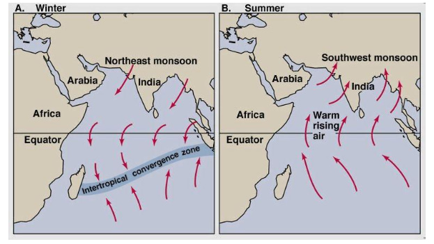
Major oceanic gyres in the world’s ocean system, acted as huge conveyor belts which influenced the navigation of sail ships. These gyres are also correlated with dominant wind flows where they rotate clockwise north of the equator and counter clockwise south of the equator (Rodrigue, 2020). Historically, maritime transport has been influenced by global wind patterns which defined maritime trade routes. For instance, maritime trade between Indian subcontinent and other parts of the world was influenced by trade winds. Ships sailed into the Indian Peninsula with the help of south west monsoon winds when the wind flow was towards the land and returned with the help of north east monsoon winds when the predominant wind direction reverses (Tripati & Raut, 2006).
The profile of the land masses of continents proves to be barriers for ship movement and hence they define the global maritime routes. This also defines the emergence of certain cities as important ports which fall along these maritime routes. The location of the eight important global maritime passages are interlinked with the geographical land formations and play a vital role in influencing global trade patterns and location of major port cities.
Location of Ports Influenced by Landscape Setting
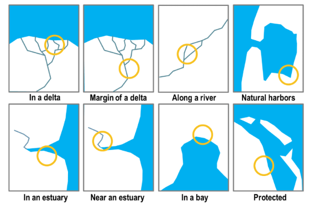
Historically, the location of port has been influenced by the physical attributes of the site where natural features (bays, sand bars, and fjords) to protect port installations (Rodrigue, 2020). Since ports were strategically located in safe locations as per geographical features, they emerged as fishing harbors and trade hubs. Owing to the kind of navigational operations, location of ports is limited to specific type of sites based on geographical suitability. Port sites were frequently chosen at the head of water navigation, the most upstream site. In case of ports along tidal waterways, the rise and fall of tides posed a challenge for ships to dock and hence such sites were situated at bays, gulfs and creeks or estuaries at the mouth of rivers.
In Rome, the maritime transport system was a reflection of the geographical characteristics and constraints of the Mediterranean basin (Rodrigue, 2020). In India, the location of Bharuch port was suitable for docking trading vessels as the Narmada River is deep and wide at this point (Shah, 2019). The land around the river Narmada was fertile and supported growth of high quality wheat and cotton which were exported and availability of good quality timber from the thick forests of Narmada valley led to the setting up of ship-building industry in Bharuch.
In India, Sopara was an island, located between the Vaitarna River and Vasai Creek. A small channel connected these two rivers flowing parallel to the coast and the ancient port of Sopara was probably located on this channel and thus, protected from the vast Arabian sea providing safe harbour for trading vessels to dock (Pandit, 2017).
Medieval roads in Europe taking advantage of natural topography
In ancient times, European pathways, with the exception of Roman roads, depended on natural topography and were seldom in good shape. During early medieval period in Europe, the Ridgeway acting as drainage divide were used by people to travel, rather than traversing through the valleys which were often densely vegetated and impeded movement. The soil along the ridges were dry due to exposure to wind and natural drainage and hence had less vegetation which was ideal for people travelling on foot and wheeled vehicles. Medieval roads, usually 4 to 9 m in width, often followed watersheds on hill and mountain ridges, averted watercourses and waterlogged areas, marshlands and those gallery forests of valley floors (Lorant, Zoltan , & Zoltan , 2011).
Geographic Setting of the Silk Route in Eurasian Landscape
The Silk Road has been a source of exchange of valuable goods, technology and diverse cultures across various regions of the globe. The geography of the Silk Roads is a complex interaction between the physical and climate zones of mountain, steppe or grasslands, and river valleys and oases which often are bounded by uninhabitable desert (Waugh, 2008). Most of the roads were situated along river courses and through places where physical features would not act as absolute barriers to movement of people and goods.
Overland Routes and Trading Cities and Ports of Ancient India
A secondary trade route branched off from the primary Silk Road and passed through Hindu Kush and Karakoram mountain ranges via Srinagar, Leh, and Sangju pass connecting Taxila and Indraprastha. The landscape setting of the various passes, namely four main connections into India allowed travellers to cross the western and eastern Himalayas and gain access into the Indian peninsula.
The Uttarapatha and Dakshinapatha were the overland arterial roads across the Indian subcontinent which traversed along river basins, and foothills of various mountain ranges. A network of secondary overland routes from the Dakshinapatha connected the port cities along the western and eastern coast of India, facilitating trade with other countries. These secondary routes were mountain passes cutting across the western ghats at specific passes at Bhor, Amba, Nane, etc. which provided access to the ports along the western coast.
Conclusion
Historically, natural topographical, climatic and technological limitations have led to the development of transport networks in close relation with the geographic constraints of the natural landscape. Since industrialization, advances in technology like mechanization and standardization have reduced the dependency of transport systems on landscape setting to a great extent. The present day transportation systems are a result of historical evolution consisting of periods of changes where older systems were being continuously replaced by newer technology driven systems.
About the Author
Abhishek Chakraborty
Landscape Architect
Abhishek, an alumni of Sir J. J. College of Architecture, Mumbai is an academician and
practicing architect. He has a masters degree in Sustainable Architecture from University of
Sheffield, UK and Landscape Architecture from L. S. Raheja School of Architecture, Mumbai.
He is the co-founder partner at Relict Landscape Collaborative LLP, Mumbai and consulting
architect at Apt, Mumbai. He is currently an Associate Professor at Pillai HOC College of
Architecture, Rasayani.
References
Lorant, D., Zoltan , I., & Zoltan , B. (2011). Geological and Geomorphological Problems Caused by Transportation and Industry. Central European Journal of Geosciences , 271-286.
NOAA. (2020, April 12). What is a gyre? Retrieved February 16, 2021, from National Ocean Service: https://oceanservice.noaa.gov/facts/gyre.html
Narayana, H. (2020, January 1). Pitalkhora – Walking the Ancient Route. Retrieved February 17, 2021, from India That Was: https://www.indiathatwas.com/2014/07/pitalkhora-walking-the-ancient-route/
National Geographic Society. (2019, July 26). The Silk Road. Retrieved February 17, 2021, from National Geographic: https://www.nationalgeographic.org/encyclopedia/silk-road
Neelis, J. (2011). Early Buddhist Transmission and Trade Networks: Mobility and Exchange within and beyond the Northwestern Borderlands of South Asia. Boston: Brill.
Pandit, S. (2017, June 2). The Legendary Sopara. Retrieved February 17, 2021, from Livehistory: https://www.livehistoryindia.com/cover-story/2017/06/02/the-legendary-sopara
Rees, G. (2010). A Hiatus in the Cutting of Buddhist Caves in the Western Deccan. Ancient Asia , 2, 119-134.
Rodrigue, J.-P. (2020). The Geography of Transport Systems (Fifth Edition ed.). New York: Routledge.
Shah, A. (2019, July 19). Bharuch – Gujarat’s Ancient Port City. Retrieved February 17, 2021, from Livehistory: https://www.livehistoryindia.com/snapshort-histories/2019/07/19/bharuch-indias-second-oldest-city
Shannon, K., & Smets, M. (2010). The Landscape of Contemporary Infrastructure. Rotterdam: NAi Publishers.
Tripati , S., & Raut, L. (2006, March 25). Monsoon wind and maritime trade: a case study of historical evidence from Orissa, India. (C. S. P. Balaram, Ed.) Current Science , 90 (6).
Waugh, D. C. (2008, August 15). The Silk Roads and Eurasian Geography. Retrieved February 17, 2021, from Silk Road Seattle: https://depts.washington.edu/silkroad/geography/geography.html
Leave a Reply